MCAS Cherry Point Background
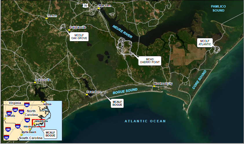
MCAS Cherry Point is a 13,164-acre military reservation north of the town of Havelock, in southeastern Craven County, North Carolina. Commissioned in 1942, MCAS Cherry Point currently provides support facilities and services for the Second Marine Aircraft Wing, houses facilities for training and supporting the Atlantic Fleet Marine Force aviation units and is designated as a primary aviation supply point. MCAS Cherry Point is also home to the Fleet Readiness Center East (FRCE, formerly the Naval Aviation Depot [NADEP]). Units at the Air Station include: (1) Combat Logistics Company 21 (CLC 21), which provides logistics support to the Second Marine Aircraft Wing); (2) Marine Transport Squadron One (VMR 1), which provided Search and Rescue support (known operationally as “Pedro”) to MCAS Cherry Point-based aircraft until September 2015 and currently provides transport of key personnel and critical logistics support to DoD; and (3) Center for Naval Aviation Technical Training Unit (CNATT), which provides specialized training in aviation maintenance to operate and maintain weapons systems.
The boundaries of MCAS Cherry Point are the Neuse River to the north, Hancock Creek to the east, North Carolina Highway 101 to the south, and an irregular boundary approximately ¾-mile west of Slocum Creek to the west.
For more information, please visit the MCAS Cherry Point Website.
MARINE CORPS OUTLYING LANDING FIELD ATLANTIC BACKGROUND
Marine Corps Outlying Landing Field (MCOLF) Atlantic is approximately 26 miles east of MCAS Cherry Point and covers approximately 1,500 acres located between Barry Bay and the Core Sound. MCOLF Atlantic has been in operation since 1942 and is an active outlying landing field that supports training operations for MCAS Cherry Point. MCOLF Atlantic has three runways and two helicopter landing zones and provides for air-to-ground exercises and limited ground operations. Current operations at the Base include rotary-wing operations in support of nearby target ranges and training activities (including tactical, air-to-ground, electronic warfare, and low-altitude exercises). The Base is also used for FARP training by MCAS Cherry Point and other Department of the Navy and Army entities.
The boundaries of MCOLF Atlantic are the Cedar Island National Wildlife Refuge to the north, Barry Bay to the northeast, and the community of Atlantic, North Carolina to the southeast.
MARINE CORPS AUXILIARY LANDING FIELD BOGUE BACKGROUND
Marine Corps Auxiliary Landing Field (MCALF) Bogue is an 837-acre outlying landing field operating under the command of MCAS Cherry Point and is located in Bogue, North Carolina, approximately 12.5 miles southwest of MCAS Cherry Point. MCALF Bogue was established by condemnation actions in December 1942. The principal function of MCALF Bogue is air operations. The Base includes a runway complex that lies within the center of the Base. Past and current operations include use of the controlled landing field for expeditionary forward Base operations by AV-8B Harriers stationed at MCAS Cherry Point. MCALF Bogue also supports fleet carrier landing practices and limited land and rotary-wing operations. It is the primary practice location for vertical short take-offs and landings of AV-8B Harriers. The United States Air Force also uses the Base for short field operations for the C-17 transport aircraft. Other functions that occupy less significant portions of the MCALF Bogue property are administrative, supply, support, utilities, and maintenance and production operations.
The boundaries of MCALF Bogue are Highway 24 to the north, Goose Creek to the east, Taylor Bay to the southeast, Bogue Sound to the south, Hunting Island Creek to the west.
MCOLF OAK GROVE BACKGROUND
MCOLF Oak Grove is a 976-acre outlying landing field currently operating under the command of MCAS Cherry Point, commissioned in August 1943. The Base consists of a runway complex located at the center of the facility, a maintenance building that contains a small office, and a storage shed along the Base access road north of the runway complex. Operations at MCOLF Oak Grove have been overseen by commands alternately associated with MCAS Cherry Point, MCAS New River, and Marine Corps Base Camp Lejeune throughout the history of the Base. FARP exercises are conducted, along with Composite Training Exercises and Marine Air Traffic Control Mobile Team exercises.
The boundaries of MCOLF Oak Grove are undeveloped land to the north and east and the Trent River to the south and west.