An official website of the United States government
Here's how you know
A .mil website belongs to an official U.S. Department of Defense organization in the United States.
A lock (lock ) or https:// means you’ve safely connected to the .mil website. Share sensitive information only on official, secure websites.

Marine Corps Air Ground Combat Center Twentynine Palms

Environmental Restoration Program Public Website

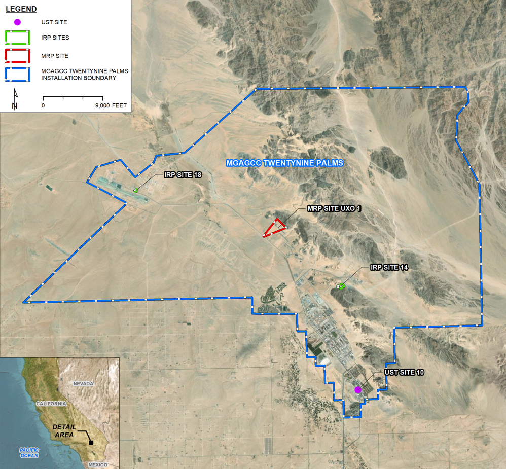
The current Installation Restoration Program (IRP), Munitions Response Program (MRP), and Underground Storage Tank (UST) sites at Marine Corps Air Ground Combat Center (MCAGCC) Twentynine Palms are managed under the Department of the Navy’s (Navy) Environmental Restoration Program (ERP). The overarching goal of Navy’s ERP is to protect human health and the environment from past hazardous waste practices and releases at Navy ERP sites. The interactive map below shows which sites are being addressed under the Navy’s ERP. At MCAGCC Twentynine Palms, the Naval Facilities Engineering Systems Command Southwest (NAVFAC SW) in San Diego, California manages the ERP.

The Navy’s program has four open ERP sites at MCAGCC Twentynine Palms. Sixty-four ERP sites have been closed. Of the four open sites, two are IRP sites, one is a UST site, and one is an MRP site.

A link to an overview of past and current environmental investigations and cleanup activities completed at each of the four open IRP, MRP, and UST sites can be found by clicking the site name on the map.

CLICK HERE for acronym definitions and a glossary of the Navy’s ERP terms.

CLICK HERE for detailed information on the Navy’s ERP.

CLICK HERE for additional site-specific documents for each IRP site in the Navy’s MCAGCC Twentynine Palms Administrative Record.

Twentynine Palms Site Map

Installation Restoration Program (IRP) Sites

Collapse All Expand All
 IRP Site 14 - Landfill No. 1

IRP Site 14, also known as Landfill No. 1, is within the MCAGCC, approximately 1 mile east of Del Valle Road and approximately 1.5 miles north of the Mainside area, the location of most of the installation support buildings and base housing. The Explosive Ordnance Disposal building is the nearest inhabited structure at approximately 130 feet northeast of the site.

From 1954 to 1972, the site was used as a landfill for disposal of installation wastes. Flammable wastes were burned at the site before disposal. Temporary covers consisting of alluvial soil approximately 1 foot thick were placed over landfill contents on a weekly basis while the site was active. During landfill operations, no permits were required for operation or closure, and a formal closure plan was not required or prepared after the landfill stopped receiving wastes in 1972 when Landfill No. 2 opened.

In 1991, a 5-foot to 10-foot-thick cover of compacted soil was placed over IRP Site 14. This cover was later overlain with a 1.6 to 3.2-foot layer of compacted crushed concrete and other construction materials. A fence was erected around the site and the site entrance was secured by a locked chain-link gate, and concrete lined drainage ditches and erosion control were installed during a 1994 removal action. Riprap is also present on the western downgradient portion of the landfill for erosion control. The area within the fence line designated as IR Site 14 is 10.9 acres.

Studies were conducted in 1992, 1996, and 2017 to evaluate contamination associated with the landfill. These studies concluded that the landfill did not pose excess risk to human health or the environment based upon the presence of the cover and control of site activities. A record of decision for IRP Site 14 was signed in 2023 documenting the selected remedy, which consists of containment, land use controls, long term monitoring, and stormwater controls. A land use control implementation plan was developed in 2023 to implement the remedy requirements.

 IRP Site 18 - CFR 4 or Crash Training Pit No. 4

IRP Site 18 is in the aircraft operations portion of the Expeditionary Airfield/Camp Wilson area, just north of the active airstrip. The three areas that comprise the site include the Crash Fire Rescue (CFR) Burn Area, the former Fuel Bladder Storage Area, and the Drainage Area. The CFR Burn Area consisted of two old, burn-area training facilities in the center of IRP Site 18. The smaller burn-area training facility was approximately 50 feet in diameter and 2 to 3 feet deep and was in use from 1977 to at least 1981. The large burn-area training facility was 85 feet in diameter and had a concrete liner and a 1-foot-deep reinforced concrete curb. The large burn area training facility was in operation from 1984 to 1991. The training pits were used to train Navy firefighting crews in the rapid extinguishment of Navy aircraft crash fires.

Environmental investigations began at IRP Site 18 in 1985 with an initial assessment study followed by a verification study, a hydrogeological assessment, and a site inspection. After the site assessments, a demonstration scale irrigation system was installed in 1995 to evaluate biodegradation.

In 1996 a bioventing system was installed to remediate the site. Groundwater monitoring occurred from 1992 to 1999. Contaminants of concern in groundwater historically consisted of total petroleum hydrocarbons and volatile organic compounds. The concentrations of contaminants showed a downward trend with time associated with the bioventing action.

An additional site investigation was conducted in 2001 followed by a human health risk assessment in 2010. Groundwater monitoring resumed in 2017 at the request of the Department of Toxic Substances Control and the Regional Water Quality Control Board contaminants of concern previously associated with IRP Site 18 were not detected, although polyfluoroalkyl substances (PFAS) compounds, an emerging contaminant of concern, were detected. The site has not yet received a finding of no further action because of the potential impacts from PFAS and will be further investigated for PFAS. More details can be found on the PFAS Data Summary and PFAS Documents tab.

Underground Storage Tank (UST) Sites

Collapse All Expand All
 UST Site 10 - Former Gas Station Buildings 1077, 1078, and 1079

The UST Site 10 facility is in the southeastern portion of the Mainside Area of MCAGCC, near the intersection of Del Valle Drive and Agate Road. The facility functioned as an active fueling and service station from construction in 1986 until the underground storage tanks (UST) were removed in 2010. The USTs, located to the southwest of former Building 1077, consisted of three 20,000-gallon fiberglass over steel tanks and one 5,000-gallon fiberglass over steel tank and supplied gasoline and diesel to the pump islands.

An accidental release of up to 7,000 gallons of gasoline occurred in March 2000 during filling of the USTs, initiating investigations and corrective actions at UST Site 10. Contaminants of concern are methyl tertiary butyl ether and petroleum compounds.

Site assessment activities began in 2000 and included several rounds of sampling and characterization culminating with a corrective action plan calling for soil vapor extraction. A pilot-soil-vapor extraction system was installed, and a remedial action plan was prepared. A full-scale soil-vapor extraction system operated from 2001 to 2007 removing more than 36,000 pounds of petroleum hydrocarbons.

An extended site investigation was conducted in 2007 because of the requirements of the planned demolition of adjacent building 1077. Following the investigation, four USTs were removed, and the buildings were demolished. Post-excavation samples indicated that no further action was warranted for soil, but that groundwater contamination was present around the former USTs. In-situ chemical oxidation was used in 2012 to treat groundwater contamination.

The Regional Water Quality Control Board requested further remediation after a 2013 UST Site 10 corrective action summary found that the in-situ treatment reduced petroleum compound concentrations but not methyl tertiary butyl ether concentrations. Additional site investigations occurred in 2015 after a 2014 corrective action plan identified data gaps.

The Regional Water Quality Control Board concurred with a 2018 corrective action plan that incorporated the additional investigative data and documented monitored natural attenuation as the selected remedy. In accordance with the plan, two years of groundwater monitoring were conducted, to be followed by site closure if the contaminant plume was stable to decreasing. In 2020, the Navy requested regulatory agency approval for site closure because the corrective action plan requirements had been met. The request for closure is currently under review by the State Water Quality Control Board.

Munitions Response Program (MRP) Sites

Collapse All Expand All
 MRP Site UXO 01 (former Ranges 106 and 107)

The former Ranges 106 and 107 are located northwest of Mainside Area of MCAGCC and the Central Magazine Area, and northeast of Rainbow Canyon Road. Former Range 106 was known as the Small Arms Remote Target System, or “SARTS” facility. The facility included 20 small arms “pop-up” targets, with a maximum target range of 1,000 meters. Former Range 107 was a mortar range where firing of 60 millimeter (mm) and 81 mm mortars occurred to the northeast with target ranges varying from 500 to 3,500 meters. The Range 107 firing line coincided with the Range 106 firing line. The use of the UXO 01 ranges ceased in 1984. Most of the former range area is undeveloped.

Because most areas of former Ranges 106 and 107 are still used for range-related training activities, only the portion deemed other than operational is included in UXO 01. The Munitions Response Program uses the term “other than operational” to describe areas that were formerly used for range-related purposes, but that are no longer considered operational ranges due to their current use or encroachment by other uses. The safety fan of the neighboring Range 101, which is currently operational, overlaps a portion of former Ranges 106 and 107. This overlapping portion remains open and is designated for active range use.

Site investigations began at UXO 01 in 2003 with a preliminary assessment. A site inspection identified munitions debris and a remedial investigation and feasibility study followed. A time-critical removal action was conducted in 2020 and 2021 which cleared surface and subsurface MEC from the site, except for a few small areas of rough and hilly terrain which were not cleared. A record of decision for MRP Site UXO 01 was signed in 2023 documenting the selected remedy, which identified land use controls and long term monitoring as the preferred alternative for the area of the site that could not be cleared. The cleared areas required no further action. A land use control implementation plan will be developed to implement the remedy requirements.

This is an Official US Navy Website • Please read this Privacy Policy • GILS NUMBER DOD-USN-000702
NAVFAC Jobs  |  FAQ  |  Search  |  Accessibility  |  FOIA  |  No Fear Act  |  Veterans Crisis Line  |  VA Vet Center  |  FVAP  |  Site Map