Collapse All Expand All


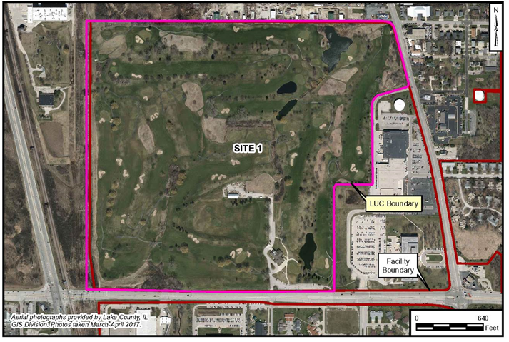
Site 1- Golf Course Landfill
Historical Use
The western half of Site 1 was historically occupied by an approximately 49-acre landfill that operated between 1942 and 1967. Waste was contained in the landfill by burning in trenches and installing a low-permeability soil cover. A dragline was used for excavation of the trenches which were 8 feet wide and extended to at least the top of the water table (approximately 6 to 8 feet deep). General refuse, trash, and free liquid oil were deposited directly into trenches which occasionally had several feet of standing water at their base. Skokie Ditch Open Channel and Skokie Ditch Pipe were located within the landfill footprint.
Between 1953 and 1955, the front 9-hole portion of the golf course was constructed east of the landfill. The clubhouse, Building 3312, and the parking lot were constructed in 1963. When the landfill was closed in 1967, a 0.5-foot layer of coal ash and a layer of soil with a minimum thickness of approximately 2 feet and an average thickness of approximately 6.5 feet were placed over the landfill. The back 9-hole portion of the golf course was constructed over the former landfill in 1968.
In 2003, sink holes occurred within the limits of Site 1. These sink holes were attributed to the collapse of the over 50-year old underground storm sewer pipe that conveyed the Skokie Ditch beneath Site 1. The clubhouse was demolished in 2007 and replaced in 2008.
Currently, Site 1 is located entirely within the limits of the 18-hole Willow Glen Golf Course. The golf course is owned and operated by the Navy and used by facility personnel and people from the surrounding area. Properties immediately adjacent to the site boundaries are generally commercial, industrial, or open space. Residential properties are located within 0.125 miles to the north, east, south, and west of the site boundary. The future use of the surrounding land and of Site 1 as a golf course is not expected to change.
The primary source of soil, sediment, groundwater and surface water contamination at Site 1 is assumed to be the former landfill activities. The landfill received approximately 1.5 million tons of waste while it was in operation as a trench/burn facility from 1942 to 1967. The volume of waste was reduced through burning, and the remaining waste is estimated to be approximately 500,000 tons. Reportedly, the waste included mostly domestic refuse; however, it also included sewage, sludge, petroleum, oil and lubricants, solvents, coal ash, and materials contaminated with polychlorinated biphenyls (PCBs).
Remedial Actions
A soil cover installed over the waste on top of the landfill prevents humans and animals from coming into direct contact with the waste, and the plugging of former storm water conveyance pipes under the landfill prevents migration of residual contaminants. Access to the site is not limited by a perimeter fence around the site; however, land use controls (LUCs) were implemented in 2011 to restrict future use of the site, prohibit installation of groundwater wells other than for environmental sampling (prohibited by Naval Station Great Lakes Instruction 11130.1 Groundwater Use Restrictions), and require annual inspections of the site to make sure LUCs are continuing to be implemented. Groundwater monitoring wells were installed in their current configuration around the perimeter of the landfill. Groundwater monitoring is being conducted at the site.
Previous Investigations
Previous investigations, plans and documentation at this site are: IAS; RI/RA; FS; PP; ROD
Current Status
LUCs have been implemented and annual long-term groundwater monitoring is being conducted.
Back to Top
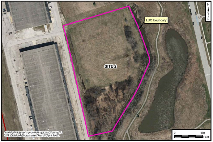
Site 2 - Forrestal Landfill
Historical Use
The Forrestal Landfill began operations in 1967 and operated for only a short period until it was closed in 1969. The landfill was the first controlled disposal site used by the Naval Station Great Lakes. The landfill boundaries are roughly 400 feet by 500 feet, covering about 4.5 acres. Historical documents indicate that wastes were not burned, and wastes disposed at the Forrestal Landfill consisted of mixed office waste and other solid wastes, and shop waste. No liquids, metals, or sanitary wastes were disposed at the landfill.
According to the Round 9 (June 2014) Groundwater Monitoring Report (Revised August 2016), the groundwater beneath Site 2 appears to mound and flows mainly to the north, but also to the south. The installation of groundwater wells (other than environmental monitoring wells) in this area is prohibited by Naval Station Great Lakes Instruction 11130.1 Groundwater Use Restrictions. LUCs are currently in place for the site to prohibit groundwater use, maintain the landfill cover, and prohibit the disturbance of soil on the site.
Site 2 is currently covered by grass and other vegetation, and the site is fenced on three sides, but access is open on the landfill’s north side. The site is not used for anything but groundwater monitoring. The Navy does not currently have any plans for development of the site. The Navy plans to maintain the engineered landfill cover, gas vents, and fence.
Remedial Actions
Investigations were conducted at the landfill in 2001 to determine the presence and extent of methane and volatile organic compounds (VOCs). Additional investigations were conducted in 2002 and 2003 to determine the thickness and other properties of the existing clay cover, and to collect groundwater samples from beneath the wastes.
A clay cap over the waste on top of the landfill prevents humans and animals from coming into direct contact with the waste. The landfill cap was reconstructed in 2004 to address settlement issues and to maintain the remedy's control of potential exposure pathways. A perimeter fence surrounds the landfill on three sides but does not limit access to the site. The remedy in place continues to be protective of human health and the environment. The LUC restricts reuse to an industrial/commercial land use scenario, under which the Site does not pose a threat to human health or the environment.
In 2006, six groundwater monitoring wells were installed in their current configuration around the perimeter of the landfill. Groundwater beneath the landfill is impacted by VOCs (below regulatory criteria), and several metals and inorganics at concentrations exceeding regulatory criteria. Annual groundwater monitoring is being conducted at the site.
Previous Investigations
These are the previous investigations conducted at Site 2: IAS; other miscellaneous investigations; Final Cover Study; EE/CA; Remedial Design Work Plan.
Current Status
LUCs have been implemented, and annual long-term groundwater monitoring is being conducted.
Back to Top
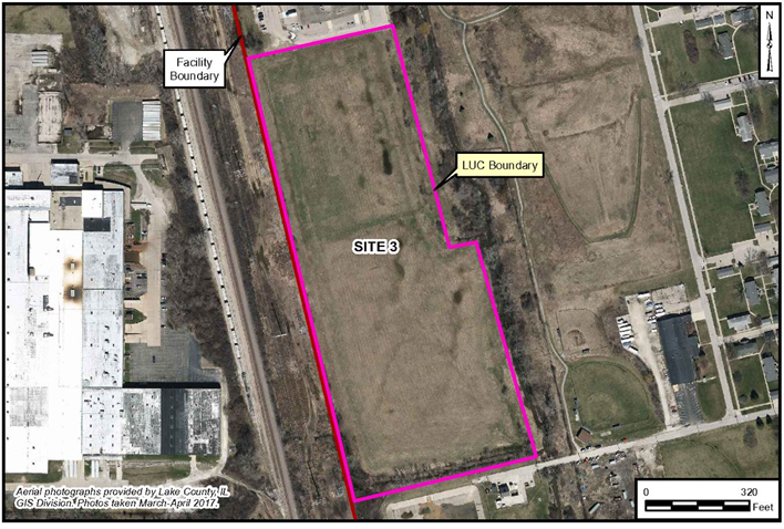
Site 3 - Supplyside Landfill
Historical Use
The Supplyside Landfill began operations in 1969 and was used until 1983. The landfill boundaries are roughly 450 feet wide by 1,400 feet long, covering about 15 acres. There are conflicting reports of the number of cubic yards of refuse that were disposed at the landfill, which was constructed of four parallel trenches. Historical documents indicate that wastes were not burned, and no hazardous wastes were disposed at the landfill. Site 3 was used to dispose of primarily office and other solid wastes.
According to the Round 9 (June 2014) Groundwater Monitoring Report, the groundwater beneath Site 3 flows towards the north. The installation of groundwater wells (other than environmental monitoring wells) in this area is prohibited to prevent the consumption of groundwater.
Site 3 is currently covered by grass and other vegetation, and the site is fenced to limit access. Activities at the property are limited to those actions that are conducted to make sure that the remedy is functioning properly, such as groundwater monitoring and inspecting cover materials and methane gas vents. The Navy placed solar panels across the site and plans to maintain the landfill cover, gas vents, and fence.
Remedial Actions
Investigations were conducted at Site 3 in 2001 to determine the presence and extent of methane and VOCs. Additional investigations were conducted in 2002 and 2003 to determine the thickness and other properties of the existing clay cap, and to collect groundwater samples from beneath the wastes.
A clay cap was placed on the landfill in 1985. The construction of the cover was completed by the Navy Construction Battalion 401, which was stationed at the Naval Station Great Lakes at the time. Between 1999 and 2001, the Navy removed the railroad tracks, filled areas between the trenches, and placed additional clay on top of the landfill.
A new cover was constructed on Supplyside Landfill in 2004. The landfill was re-graded to create a flat surface with a gradual slope across the top of the landfill. A three percent slope was created on the top surface for drainage and erosion control, and a 3-to-1 slope was created around the perimeter of the landfill. The final cover construction included of 18 inches of low permeability clay with 6 inches of topsoil to support vegetative growth. A passive vent system was installed that consisted of shallow trenches excavated in the waste material, with horizontal collector pipes and vertical vent pipes. Asbestos-containing material was identified in the topsoil cover in 2004. Material for the clay and topsoil were generated from site grading activities at a construction site located at the Recruit Training Center. Geotextile fabric and additional clay were placed in 2005 over a 330-foot by 550-foot area at the north end of the landfill to cover about 12,000 cubic yards of soil with asbestos-containing material (non-friable transite).
A perimeter fence around the landfill limits access to the site. LUCs are in place to prohibit groundwater use (prohibited by Naval Station Great Lakes Instruction 11130.1 Groundwater Use Restrictions), maintain the engineered landfill cover, and prohibit the disturbance of soil on the site. The remedy in place continues to be protective of human health and the environment.
Six groundwater monitoring wells were installed in their current configuration around the perimeter of the landfill. Groundwater beneath the landfill is impacted by semi-volatile organic compounds (SVOCs), herbicides, and several metals and inorganics at concentrations exceeding regulatory criteria. Annual groundwater monitoring is being conducted at the site.
Previous Investigations
These are the previous investigations that have been conducted: IAS; other miscellaneous Investigations; Soil Cover Placement; EE/CA; Remedial Design/Cap Work Plan.
Current Status
LUCs have been implemented, and annual long-term groundwater monitoring is being conducted.
Back to Top
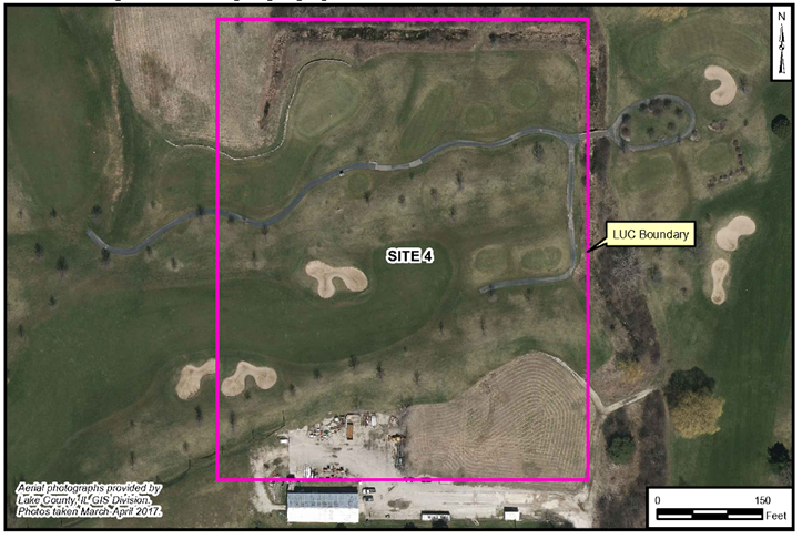
Site 4 - Fire Fighter Training Unit
Historical Use
Site 4 was a 10-acre fire fighter training unit (FFTU) used between 1942 and 1989 to train naval recruits in the fundamentals of firefighting. The former FFTU was located near the center of the 18-hole Willow Glen Golf Course (Site 1). The current golf course is owned and operated by the Navy and used by facility personnel and people from the surrounding area. Properties immediately adjacent to the golf course are generally commercial, industrial or open space. Residential properties are located within 0.125 miles to the north, east, south and west of the site.
Fuels in open burn pits, concrete carrier compartments and gasoline burning compartments were ignited to simulate fires. Fuels were transported to the site through pressurized underground piping. Unburned fuels and wastewater were drained from the burn area and treated using separators and decant ponds on the western side of the FFTU. Treated wastewater and storm water discharged through a storm sewer into Skokie Creek, approximately 0.25 miles west and south of the site.
The primary source of contamination to subsurface soil and groundwater at Site 4 was attributed to petroleum products (diesel fuel and gasoline) that were stored onsite and used during firefighting training exercises. Contaminants of concern (COCs) included polycyclic aromatic hydrocarbons (PAHs) and VOCs in subsurface soil; and metals, PAHs and VOCs in groundwater.
Remedial Actions
The piping and subsurface vaults, tanks, pits, sludge pits, soil, and other features were successfully removed, sorted, and characterized for appropriate disposal and/or treated on site. Biopiles were constructed on site in accordance with a pre-approved remediation design to treat petroleum-contaminated soil using ex-situ bioremediation techniques. As identified in subsequent investigations, some residual soil contamination remained at the site following cleanup activities.
The Sites 1 and 4 Record of Decision (ROD) was signed in 2010. A soil cover over the former FFTU prevents humans and animals from coming into direct contact with the contaminated soil. Access to the site is not restricted; however, LUCs were implemented in 2011 to restrict future use of the site, prohibit installation of groundwater wells other than for environmental sampling (prohibited by Naval Station Great Lakes Instruction 11130.1 Groundwater Use Restrictions), and require annual inspections of the site to make sure LUCs are continuing to be implemented. Monitoring wells were installed in their current configuration around Site 1. Groundwater monitoring is being conducted at the site.
Previous Investigations
Previous investigations, plans and documentation at this site are: IAS; RI/RA; FS; PP; ROD.
Current Status
LUCs and been implemented, and annual long-term groundwater monitoring is being conducted.
Back to Top
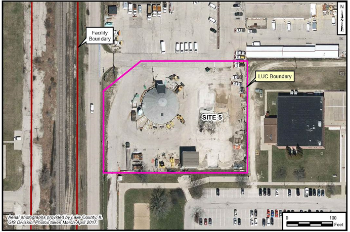
Site 5 - Transformer Storage Boneyard
Historical Use
This site was the primary storage area for out of service transformers, (including PCB-containing transformers) from 1945-1985. According to the 1986 IAS, at least six transformers reportedly containing PCB oils were stored between 1979 and 1981 on the basement floor level of Building 226. This building has since been razed. In 1981, while the transformers were reportedly stored in the building, vandals removed the tops from six of them, spilled the contents onto the floor and stripped out the copper cores. The entire contents of the transformers (approximately 132 gallons of oil) were reportedly lost into the soil of the 100 square-foot storage area. Site conditions determined from the IAS indicated that there was a potential for soil contamination as a result of the spill, and also a potential for contaminant migration and exposure by potential receptors.
Remedial Actions
A RI Verification Step was conducted in 1991 to collect and analyze soil samples to verify the presence of PCBs at the site; determine the approximate degree of contamination (if present); and plan an extended monitoring program (if required) or recommend no further action if PCB’s were not found.
According to the IAS, no cleanup of the site was conducted. The transformers were removed in 1985 and the area is currently used for road maintenance storage.
Soil sampling at the Mainside Transformer Storage Area was conducted in two phases, the first taking place in September 1987 and the second in June 1988. The results of sampling and analysis indicated that no PCB contamination of shallow soil occurred in the vicinity of and downgradient of Building 226; and that any contaminated soil had eroded or otherwise been removed, so that no residual contamination remained in the shallow soil of the area sampled. This included the area of the interior floor of the Building 226 basement where the spill reportedly occurred.
A RI conducted in 2010 and 2012 investigated soil and groundwater at Site 5. Using data from the 2010 and 2012 investigations, a risk assessment identified unacceptable risk under future residential and industrial/commercial land use scenarios from exposure to PAHs and several metals in soil, and one VOC and several metals in groundwater. Concentrations of PAHs in soil exceeded criteria protective of industrial/commercial and construction workers.
The Site 5 ROD was signed in 2014 which documents a remedy of LUCs to prevent exposure to contaminated soil and prevent groundwater use as a potable source. LUCs were implemented in May 2016 to restrict future use of the site, prohibit installation of groundwater wells other than for environmental sampling (prohibited by Naval Station Great Lakes Instruction 11130.1 Groundwater Use Restrictions), and require annual inspections of the site to make sure LUCs are continuing to be implemented.
Previous Investigations
Previous investigations, plans and documentation at this site are: IAS; RI/RA; FS; PP; ROD.
Current Status
LUCs have been implemented.
Back to Top
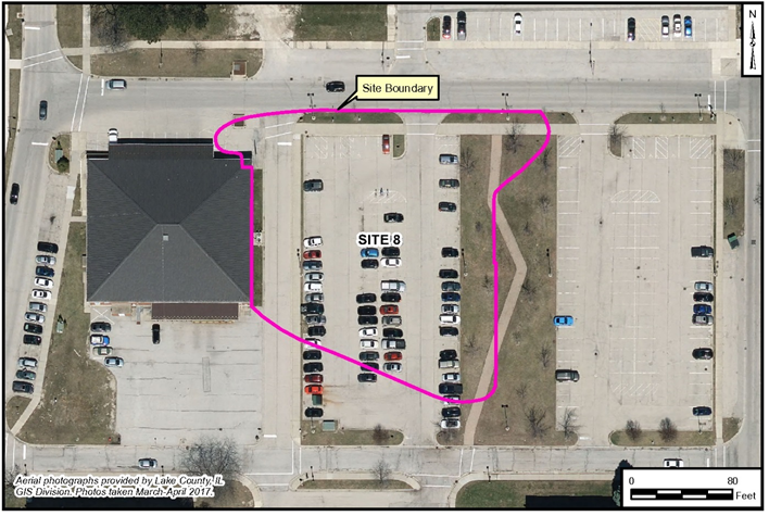
Site 8 – Exchange Service Station
Historical Use
Building 145 was constructed in 1960 as a gasoline service station. It was a slab on grade foundation of approximately 1,664 square feet with an attached storage shed of 400 square feet. A hazardous waste storage area was on the site for limited storage of paint/solvents and waste oil. The facility and all associated structures (UST, and oil-water separator [OWS]) were removed in 2001.
In 1983, a major gasoline spill occurred at the Navy Exchange service station (Building 144/145) on the Mainside area of the activity. Approximately 3,000 gallons of gasoline were spilled when a line leading to the underground storage tanks ruptured.
Remedial Actions
Product recovery wells were installed to pump out the contaminated gasoline. The recovered fuel was delivered to the Fire Fighting Training Area for disposal. After the recoverable gasoline was removed from the ground, contaminated soil was also removed for off-base disposal. A 24-hour fire watch was put in effect, and the area was monitored by the Fire Department for a month following the spill.
Despite the thorough cleanup at the spill site, the odor of gasoline was still detected in the basement of the nearby Post Office (Building 112) after heavy rain in the years following the spill per the IAS. Apparently, residual gasoline remaining in the subsurface gets displaced by percolating rainwater and enters the lowest levels of the building.
Contaminants of concern are PAHs that exceed residential soil standards for the ingestion pathway. Building 145 does not pose a threat to human health or the environment under an industrial/commercial land use scenario. With the installation of an asphalt parking lot, an engineered barrier exists preventing ingestion of soil. The asphalt is 3 inches in thickness and is maintained by the Great Lakes Public Works Center ensuring the integrity of the cover. LUCs are in place with property use restrictions and the installation of groundwater wells (other than environmental evaluation or monitoring wells) is prohibited by Naval Station Great Lakes Instruction 11130.1 Groundwater Use Restrictions).
Previous Investigations
Previous investigation at this site is the IAS.
Current Status
The site has been recommended for additional study.
Back to Top
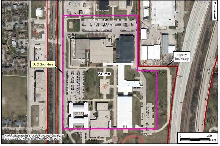
Site 9 - Camp Moffett Ravine Fill Area
Historical Use
In 1980, during the repair of a collapsed portion of roadway in the Camp Moffett Ravine, fill material consisting of a variety of galley-type wastes were excavated. There was no information to suggest that hazardous waste disposal occurred at the Camp Moffett Ravine Fill Area; however, Naval Station Great Lakes personnel stated that various wastes and materials were placed in a hole where three former ravines converged in the area along the east side of Camp Moffett.
In addition, during 2003 excavation, activities associated with construction of Building 1425, Combat Training Pool, galley-type wastes were also encountered. During the 2005 and 2006 construction of the new Recruit Processing Facility and Uniform Issue Building, non-hazardous material/debris was excavated while digging the footers for the foundation. Geotechnical boring logs for the design of the foundation of the new Recruit Processing Facility and Uniform Issue Building describe fill material including cinders, cobbles, concrete, glass and brick.
Remedial Actions
The RI was conducted to determine the nature of fill material(s) that were placed in three former ravines (which are also described as being three "fingers”), and to identify potential risks associated with Site 9. The chemical data for Site 9 (groundwater and subsurface soil) were used to conduct a Human Health Risk Assessment (HHRA). Exposure of ecological receptors to site contaminants was expected to be minor based on the industrial nature of the site and lack of suitable habitat; therefore, it was not necessary to evaluate potential risks to ecological receptors at the site.
The site investigation also considered whether the movement of site groundwater could pose a threat to off-site areas. Groundwater from the site may be collected in the stormwater piping that discharges into the unnamed tributary to Pettibone Creek east of Sheridan Road. If the groundwater is contaminated, it could contribute to surface water contamination in the tributary. Investigations of Pettibone Creek and the unnamed tributary of Pettibone Creek did not identify surface water contamination, nor whether Site 9 groundwater is a potential contamination source.
The RI was completed in two phases. A geophysical survey was completed prior to Phase I of the RI to determine the edges of the fill area related to the former ravines; this information was used to guide the subsequent media sampling efforts. Phase I of the RI fieldwork was conducted in September 2009 and consisted of the drilling of soil borings, and collecting soil samples for laboratory analysis. Phase II of the RI fieldwork was conducted in November 2009 and consisted of installing permanent groundwater monitoring wells, collecting groundwater samples for laboratory analysis, and surveying of the groundwater monitoring wells.
The Site 9 ROD was signed in 2014. The selected remedy for Site 9 includes LUCs to make sure the property is not developed for residential or non-residential special uses (such as parks, day care, or schools). Potential construction plans would have to be reviewed to protect workers and confirm proper management of contaminated media prior to construction activities. LUCs also prevent groundwater use (prohibited by Naval Station Great Lakes Instruction 11130.1 Groundwater Use Restrictions) and stipulate that existing pavement , buildings, and maintained grassy areas are used as barriers to prevent exposure to contamination. The barriers are required to remain intact. LUCs were implemented in May 2016.
Previous Investigations
Previous investigations, plans and documentation at this site are: IAS; RI/RA; FS; PP; ROD.
Current Status
LUCs have been implemented at this site.
Back to Top
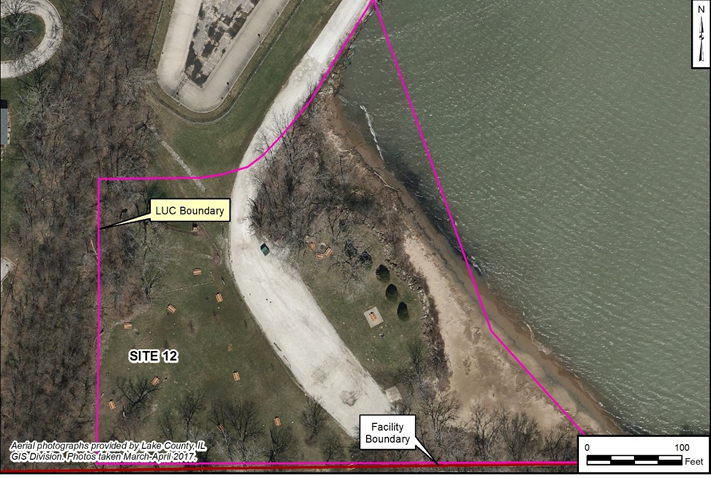
Site 12 - Harbor Dredge Spoil Area
Historical Use
During harbor dredge activities in 1952 and the 1970s, dredge spoils were reportedly disposed in this area. The sediment dredged from the harbor may have high organic content and potentially contain heavy metals, oils, pesticides, and PCBs. The primary sources for the environmental contaminants in the sediments are from non-Navy upstream industrial sources (historical discharges and contamination), and non-Navy and Navy storm water discharges within the Pettibone Creek Watershed. Overland runoff and storm water discharges from Naval Station Great Lakes to Pettibone Creek may have historically contributed pollutants to the watershed; however, the Navy currently manages discharges through the appropriate storm water management regulations, and recent analytical results indicate that no significant Navy point sources are impacting the sediment quality of Pettibone Creek.
Remedial Actions
A RI was conducted to determine the nature of fill material(s) that were placed in the Harbor Dredge Spoil Area, and to identify potential risks associated with Site 12. The chemical data for Site 12 were used to delineate areas of impacted soil/fill, evaluate the potential for metals to migrate to groundwater, and conduct a HHRA and an Ecological Risk Assessment for the site.
The RI was completed in three phases. The RI fieldwork conducted in December 2010 and December 2012 consisted of the drilling of soil borings, and collecting and analyzing soil samples. The RI fieldwork conducted in August 2013 consisted of installing monitoring wells, and collecting and analyzing groundwater samples.
The Site 12 ROD was signed in 2016, and documents a remedy including LUCs. LUCs were implemented in 2017 to restrict future use of the site, prohibit installation of groundwater wells other than for environmental sampling (prohibited by Naval Station Great Lakes Instruction 11130.1 Groundwater Use Restrictions), and require annual inspections of the site to make sure LUCs are continuing to be implemented.
Previous Investigations
Previous investigations, plans and documentation at this site are: IAS; RI/RA; FS; PP; ROD.
Current Status
LUCs have been implemented at this site.
Back to Top
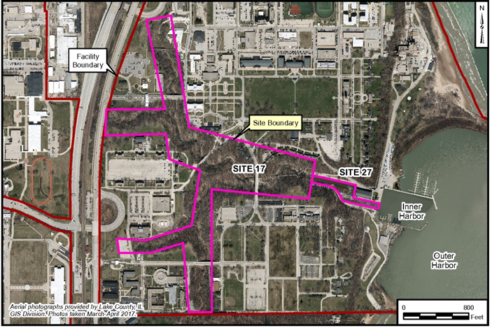
Site 17 - Pettibone Creek and Site 27 – Boat Basin
Site Description
Pettibone Creek sediments contain elevated concentrations of SVOCs, pesticides, and metals, and to a lesser extent VOCs and Aroclor 1254. The data indicate that Pettibone Creek (Site 17) has been the primary migration route for contaminants to enter the Boat Basin (Site 27), and consequently the Inner and Outer Harbors.
Contaminants present in the Boat Basin (Site 27), Inner Harbor, and the Outer Harbor sediments appear to have originated from unidentified sources located upstream from Naval Station Great Lakes in the city of North Chicago, and from unidentified sources located on Naval Station Great Lakes property. The relative proportion of the contaminants derived from these two general sources is unknown.
Remedial Actions
Samples were collected by United States Environmental Protection Agency (USEPA) contractor from Pettibone Creek upstream of the Inner Harbor on May 22, 1980. Site investigations were conducted at the Naval Station Great Lakes Harbor in April 1988, April 1989 and December 1989 to evaluate dredging and disposal options for potentially contaminated sediments in the Boat Basin, the Inner Harbor, and the Outer Harbor. In August 1991, the Navy issued a contract task order requesting that further investigation, in the form of an SI be conducted at the Boat Basin, the Inner Harbor, and the Outer Harbor. A report and a technical memorandum were completed that presented the results of sediment and surface water sampling of Pettibone Creek, Boat Basin, Inner Harbor, Outer Harbor and Lake Michigan in August 1992.
A RI/RA was conducted in 2001 for Pettibone Creek and the Boat Basin. A Sediment Characterization investigation for Pettibone Creek was conducted in 2012. A 2013 ROD for Pettibone Creek notes that no action is necessary to protect public health or the environment.
Remedial alternatives, a revised FS and PP for the Boat Basin were prepared. The ROD for the Boat Basin is being developed and is anticipated to be completed in the Spring of 2021. LUCs are the planned the remedy for the site. LUCs will be implemented in 2021 or 2022 to restrict future use of the site and require annual inspections of the site to make sure LUCs are continuing to be implemented.
Previous Investigations
Previous investigations, plans and documentation at this site are: RI/RA; FS; Sediment Characterization Report in Support of the FS; PP; ROD. Investigations for the Boat Basin were: SI; RI/RA; FS; PP; ROD.
Current Status
No Further Action is required for Pettibone Creek.
A LUC implementation plan for the Boat Basin is being developed.
Back to Top
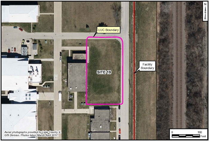
Site 19 - Small Arms Range Building 910
Historical Use
The former Recruit Training Center (RTC) Rifle Range had been located in Building 910 since 1942, and remained in operation for approximately 58 years until the demolition of the building in 2000. It is estimated that 19 million pounds of spent ammunition were generated by this facility. Chemicals primarily composed from petroleum products and distillates (i.e., VOCs and PAHs) were used on rags as a cleaner at the Rifle Range and were disposed of in the dumpsters, along with the empty cans.
A former dry cleaning facility is located just southwest of the former Building 910. Dry cleaning operations have been active for over 50 years. A Resource Conservation and Recovery Act (RCRA) storage unit and tanks were located at the northern end of the dry cleaning facility, approximately 80 feet southwest of Site 19.
Remedial Actions
In 1998, prior to the demolition of Building 910, two soil samples were collected adjacent to the building. The building was demolished in August 2000, and the site was covered with 12 inches of topsoil and hydroseeded. Soil samples were also collected in 2001 on Lake County Property located east of Building 910, two of which were collected near Site 19. One sample was collected slightly north and east of Site 19, and another was collected southeast of Site 19.
A RI/RA was conducted to collect soil and groundwater samples and the report was prepared in 2010. A Focused Feasibility Study was prepared in 2012. A 2013 ROD documented LUCs as the remedy for the site.
LUC objectives are to prohibit unacceptable risk from exposure to contaminated soil under residential use scenarios, and to restrict disturbance of surface and subsurface soil. There is a prohibition of residential and non-residential special uses (such as for child-care facilities, pre-schools, elementary schools, secondary schools, playgrounds, convalescent or nursing care facilities) for a population that requires special protections. Also, the installation of groundwater wells (other than environmental evaluation or monitoring wells) is prohibited by Naval Station Great Lakes Instruction 11130.1 (Groundwater Use Restrictions).
Previous Investigations
Previous investigations, plans and documentation at this site are: a site investigation; RI/RA; FS; PP; ROD.
Current Status
LUCs have been implemented at the site.
Back to Top
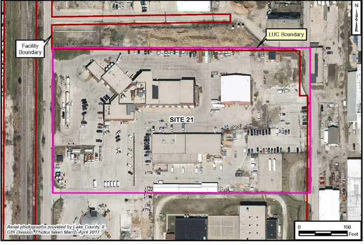
Site 21 - Building 1517/1506 Area
Historical Use
The area north of Building 1517 may have been used to store waste or scrap material on concrete pads next to rail spurs from the 1930s to 1940s. These materials may have been hauled away by railcar, or sent to an incinerator which was located in the northwest portion of the site until 1964. Prior to 1950 until the 1960s or 1970s, the site was used as a coal stockpile area, which covered most of Site 21 north of Building 1517. The site was historically associated with salvage operations. Building 1517 is currently used for equipment storage.
Site 21 contained several buildings and parking lots, was almost entirely covered by buildings and pavement. A storage building is located south of Building 1517 and is used by the paint, plumbing, and electrical shops and others. A temporary hazardous waste storage area is located next to Building 1517 at the southwest corner. Building 1506, located in the northwestern portion of Site 21, houses offices along with the garage and fueling station for base support and government vehicles.
Remedial Actions
A RI was completed in 2012. The RI was completed in two phases. A geophysical survey was completed prior to Phase I of the RI to determine the edges of suspected disposal areas related to the Site 9- Camp Moffett Ravine Fill Area, which is mostly located within the boundary of Site 21. This information was used to guide the subsequent media sampling efforts. Phase I of the RI field work was conducted in September 2009 and consisted of the drilling of soil borings, and collecting and analyzing soil samples. Phase II of the RI fieldwork was conducted in November 2009 and consisted of the installing a permanent groundwater monitoring well, collecting and analyzing groundwater samples, and surveying the groundwater monitoring wells.
Soil was determined to have VOCs, SVOCs, pesticides and herbicides, PCBs, dioxins and furans, and metals at concentrations exceeding screening criteria. Groundwater samples collected during RI activities had VOCs, SVOCs, pesticides and herbicides, and metals at concentrations greater than screening criteria.
A Focused FS Report was prepared in October 2013. A PP was completed in February 2014. The Site 21 ROD was signed in 2014, and describes a remedy including LUCs to restrict use of the site and make sure contaminated soils are covered by a barrier to prevent exposure. LUCs were implemented in May 2016. Also, the installation of groundwater wells (other than environmental evaluation or monitoring wells) is prohibited by Naval Station Great Lakes Instruction 11130.1 (Groundwater Use Restrictions).
Previous Investigations
Previous investigations, plans and documentation for this site are: RI/RA; FS; PP; ROD.
Current Status
LUCs have been implemented at the site.
Back to Top
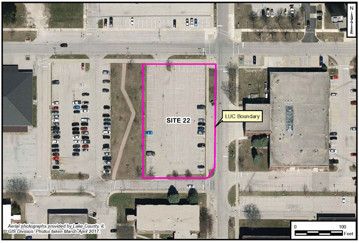
Site 22 – Former Building 105 Old Dry Cleaning Facility
Historical Use
Former Building 105 operated as a dry cleaning facility between 1939 and 1993. VOCs may have been discharged to the sanitary and storm sewer systems during the facility operations or as a result of occasional spills. From 1993 or 1994 until February 2001, the building was used to warehouse and repair vending equipment and products. The vending machine supply and repair operations ceased in February 2001, and the building was vacant until it was demolished in March 2003 and replaced by an asphalt parking lot with a high-density polyethylene (HDPE) liner. The site is now an active, paved parking lot.
Hazardous waste/materials associated with the dry cleaning facility, typically containing tetrachloroethene (PCE), were stored inside the building between 1980 and 1987. The quantity of waste/material stored in Building 105 is unknown. According to the revised RCRA permit for the site, the maximum amount allowed to be stored at one time was 165 gallons (i.e., three 55-gallon drums). The storage area consisted of the concrete floor of the building adjoining the concrete block exterior wall along the eastern side of Building 105. There were no berms or curbs associated with the storage area. Several floor drains were located near the storage area. According to historical foundation plans, these drains were connected to the storm sewer system outside the building. The building foundation plans depicted two 6-inch drains under the washing machines in Building 105. The drains were connected to a grease catch basin outside the southeast corner of the building. The catch basin was approximately 5 feet by 7.5 feet by 5.5 feet deep. It included two chambers and had a 6-inch tile effluent pipe. The effluent line may have been connected to a manhole outside the building along Sampson Street, and ultimately to the wastewater sewer lines for Naval Station Great Lakes.
Current land use of Site 22 as a parking lot is not expected to change in the foreseeable future. The parking lot currently serves personnel in the fire station (Building 106), post office (Building 112), gymnasium (Building 4), security administration (Building 6), staff barracks (Building 178), and clinic (Building 237).
Remedial Actions
The former dry cleaning operations conducted at Site 22 are believed to be the primary source of soil and groundwater contamination at the site. PCE was used as part of the former dry cleaning operations, and was stored in an AST. In addition, drums containing waste PCE were stored in a RCRA storage unit located inside of Building 105. Soil and groundwater contamination can be attributed to occasional spills during facility operations, discharges to storm sewers, and/or damaged/leaking sanitary or storm system facilities.
Soil and groundwater impacts were delineated through a series of phased investigations that occurred from 2001 through 2004. PCE and cis-1,2-dichloroethylene (DCE) were identified as the COCs in site soil and groundwater. Impacted soil was identified to a maximum depth of 30 feet below ground surface (bgs), with the highest concentrations occurring between 7 and 20 feet bgs nearest the former grease catch basin. Groundwater impacts were limited to shallow depths adjacent to the former grease catch basin. The major source area was estimated to be 625 square feet, encompassing a volume of approximately 600 cubic yards.
An interim remedial action for Site 22 consisted of a focused electrical resistance heating (ERH) study, implemented in 2006, which was successful in reducing soil contaminant concentrations. However, contaminants remain in place at concentrations exceeding criteria that allow for unrestricted use. The Site 22 ROD was signed in 2008. An engineered barrier (an impermeable liner and asphalt pavement) was installed in 2009 that prevents direct contact with residual contaminants. LUCs were implemented in 2009 to restrict future use of the site to industrial/commercial scenarios, prohibit installation of groundwater wells other than for environmental sampling (prohibited by Naval Station Great Lakes Instruction 11130.1 Groundwater Use Restrictions), and require annual inspections of the site to make sure LUCs are continuing to be implemented. The remedy in place continues to be protective of human health and the environment. In addition, construction activities and intrusive work of any kind at the site must be forwarded to the Naval Facilities Engineering Command (NAVFAC) Environmental Business Line Core for review, certification, and approval in accordance with the LUC Implementation Plan and Base Master Plan. The approval process is to ensure worker safety as required under state and federal regulations.
Previous Investigations
Previous investigations, plans and documentation for this site are: RI/RA; FS; ERH Treatability Study (Interim Remedial Action); PP; ROD.
Current Status
LUCs have been implemented at this site.
Back to Top
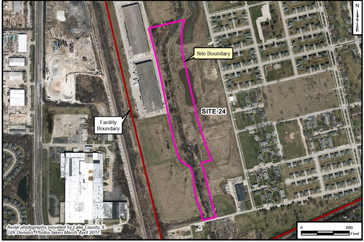
Site 24 – Panhandle Fill Area
Historical Use
No site documentation is available; however, the Panhandle Fill Area was known to Navy personnel as a fill area. No records of fill materials, boundaries, or activities are available. Within the fill are two small and distinct waste areas with a maximum thickness of approximately 12 feet. The waste consists of general refuse such as paper, glass, plastic, cardboard, and wood. The most significant constituents detected are VOCs in groundwater, and metals and PAHs in soil and sediment. Metals and PAHs are widely detected at the site. While some site detects are above published and accepted background levels, the widespread nature and consistent concentrations of detects at the site suggests that metal concentrations at the Panhandle Fill Area are from background soils.
Remedial Actions
A RI/RA was initiated in 2012 by the Navy, and has been completed at the site. Human health risk assessment results show that the potential incremental lifetime cancer risk (ILCR) exceeds the EPA risk management range for exposure to groundwater for the age-adjusted trespasser due to concentrations of arsenic, dioxin toxic equivalents, and Aroclor 1242 in groundwater. Hazard indexes for the occupational worker and construction worker exposed to subsurface soil and the child trespasser exposed to groundwater are above the EPA target non-cancer hazard index (HI) of 1. The HIs are driven primarily by concentrations of metals. Concentrations of lead in sediment may cause unacceptable health risks to a child resident and construction worker. The ecological risk assessment results indicate that there is potentially unacceptable ecological risk to ecological receptors from direct contact exposure to zinc in site soils and several metals and chlorinated pesticides in Skokie Creek sediment. A remedial design was prepared to excavate the waste material and contaminated soil for disposal at a permitted landfill, and restore the site.
Previous Investigations
A RI/RA has been completed at this site. An EE/CA and Action Memorandum were developed to address the planned removal action including excavation and off-site disposal of waste and contaminated soil.
Current Status
A non-time critical removal action began in December 2020.
Back to Top
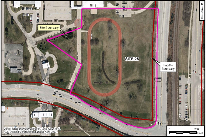
Site 25 – Camp Moffett South Fill Area
Historical Use
There is limited historical information regarding the site. The exact extent of the Camp Moffett Southern Fill Area is not known; however, it appears to be an approximately 9-acre area bounded by Buckley Road to the south, Kansas Street to the west, and Route 137 and Sheridan Road to the east. The fill area was located on Navy property within a fenced and restricted area. Past excavations in the area uncovered small bottles that were possibly consistent with disposal of medical wastes. Site walkovers noted the presence of asbestos-containing material within surface soil. Fill ranges from 2 and 15 feet thick across the site, consisting primarily of reworked native soil. The upper portion of fill contains trace amounts of construction debris. The most significant constituents detected are metals, and to a lesser degree, PAHs.
Remedial Actions
A RI/RA which was initiated in 2012 has been completed at the site. The human health risk assessment shows that the ILCR for the evaluated receptors exposed to surface soil or subsurface soil is within or below the EPA target cancer risk management range. The evaluated receptors exposed to surface soil, subsurface soil, and groundwater have HIs that are below the EPA target HI of 1 under both the RME and CTE scenario for each media. ILCRs and HIs were not estimated for the residential evaluation. Instead, risk-based remediation goals were developed for each COPC by media and compared to the COPC concentration of the corresponding media for each sample location. Results of this comparison indicate that further evaluation, with respect to surface soil, subsurface soil, and groundwater exposure may be required for the hypothetical future resident. Risk to ecological receptors is considered acceptable. An FS is being prepared to evaluate remedial alternatives for several metals, detected asbestos, and exposed debris on the southern third of the site. A surface water drain on the south slope of the area overflows and cut deeply into the topsoil, potentially exposing fill material.
Previous Investigations
A RI/RA and an FS have been completed at this site.
Current Status
A PP and ROD is in progress for this site.
Back to Top
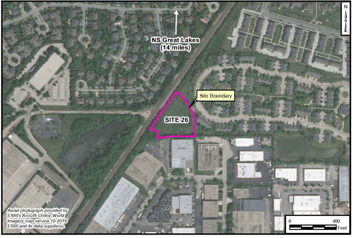
Site 26 – Western Landfill – NAS Glenview
Historical Use
The former Western Landfill is a 2.2-acre parcel that was part of the former Naval Air Station (NAS) Glenview. The site was used as a landfill in the mid-1950s where waste from the base was buried or burned. The landfill was closed in the late 1950s to early 1960s. The disposed and burned waste included base-generated refuse, from office to household-type garbage, and construction debris. Oils, fuels, and solvents may also have been disposed of at the landfill.
As part of an Interim Remedial Action (IRA) in 2000, a clay cap was constructed over the primary waste areas to limit potential exposure and reduce the infiltration of rainwater. This action also included the installation of a fence to control site access.
Remedial Actions
A comprehensive Remedial Investigation/Feasibility Study (RI/FS) was conducted between 2013 and 2018 to fully characterize the site and evaluate long-term cleanup solutions. The investigation concluded that while the site was safe under current conditions, potential unacceptable human health risks could exist for hypothetical future residents, construction workers, or commercial workers if the waste was left in place.
Based on this analysis, the Navy and Illinois EPA signed a Record of Decision (ROD) on September 25, 2018, formalizing the selection of a final remedy. After comparing four alternatives, the agencies selected Alternative 4: Waste and Contaminated Soil Excavation, Off-Site Disposal, Restoration for Reuse.
This selected remedy is the most protective long-term solution and involves:
-
Complete excavation of all waste and contaminated soil.
-
Transportation and proper disposal of all excavated material at a licensed, off-site landfill.
-
Confirmation sampling to ensure all cleanup goals are met.
-
Backfilling the site with clean soil, restoring it with top-soil, and seeding with native plants.
The primary benefit of this remedy is that it will restore the site to a condition suitable for Unlimited Use/Unrestricted Exposure (UU/UE), meaning no future land use controls or long-term monitoring will be required.
Previous Investigations
Several investigations have been completed at Site 26 since the mid-1990s. The key reports that led to the final remedy include:
-
Final Gray Sites Phase II Report (1996): Initial investigation that recommended further action.
-
Engineering Evaluation/Cost Analysis (EE/CA) Report (1999): Provided the basis for the interim action of capping the landfill.
-
Phase I/II Environmental Site Assessments (2005): Identified contaminants exceeding residential screening levels and recommended further risk evaluation.
-
Remedial Investigation/Focused Feasibility Study (RI/FFS) Report (2018): Provided the detailed analysis of risks and comparison of cleanup alternatives that supported the final Record of Decision.
Current Status
Per the Record of Decision, signed on September 25, 2018, the selected remedy is Complete Excavation, Off-Site Disposal, and Restoration for Reuse. A removal action is planned for Spring of 2026. The goal of the project is to remove the landfilled wastes entirely along with all contaminated soils exceeding the site cleanup goals and restoring the property for safe and unrestricted community use.
Back to Top